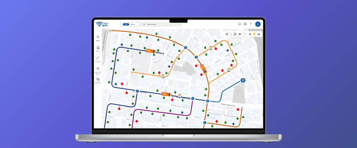
GIS Map
A Next-Generation GIS Mapping Solution for Smarter Decision-Making
GIS MAP is a powerful Geographic Information System (GIS) platform designed to provide users with precise mapping, spatial analysis, and real-time data visualization capabilities. Built for professionals, researchers, and organizations, GIS MAP combines cutting-edge geospatial technology with an intuitive user experience to help users make smarter decisions, streamline workflows, and uncover insights hidden in geographic data.
1. Interactive Mapping Interface
GIS MAP features an intuitive, interactive mapping interface where users can visualize geographic data with high accuracy. With tools for zooming, panning, and layering, users can explore, customize, and analyze maps effortlessly.
2. Real-Time Data Integration
The app supports real-time data integration, allowing users to overlay live data streams such as weather patterns, traffic conditions, and infrastructure updates. This feature ensures that users always work with the most current and accurate information.
3. Customizable Layers and Overlays
GIS MAP allows users to add, edit, and organize map layers to analyze different datasets simultaneously. From population density and land usage to utility networks, the app empowers users to overlay and visualize diverse geospatial data with ease.
4. Advanced Spatial Analysis Tools
The app provides advanced spatial analysis features, including buffer zone analysis, heat mapping, elevation profiling, and proximity calculations. These tools help users uncover trends and relationships within their data for better decision-making.
5. Multi-Industry Applications
GIS MAP caters to a wide range of industries, including urban planning, logistics, agriculture, disaster management, and environmental studies. Its versatility makes it the go-to solution for professionals across diverse domains.
6. Offline Access
With GIS MAP, users can download maps and data for offline use, making it an ideal solution for fieldwork in remote areas where connectivity is limited. Offline capabilities ensure uninterrupted access to essential tools and data.
7. Seamless Data Import and Export
GIS MAP supports multiple file formats, such as shapefiles, KML, GeoJSON, and CSV, ensuring seamless data integration and compatibility. Users can easily import external datasets or export their results for use in other applications.
8. Dynamic 3D Mapping
The app includes 3D visualization tools for terrain modeling, city planning, and infrastructure mapping. This feature provides users with a more immersive and detailed view of geographic data for better analysis and presentation.
9. Mobile and Web Integration
GIS MAP is designed for both mobile and desktop platforms, allowing users to access their projects and data from anywhere. Synchronization across devices ensures a seamless user experience whether in the office or out in the field.
10. Real-Time Collaboration
The app supports real-time collaboration, enabling teams to work on the same maps and projects simultaneously. With tools for commenting and sharing, users can enhance teamwork and streamline communication.
11. Powerful Search and Query Functions
GIS MAP includes advanced search and query tools to filter and locate specific data points. Whether searching for nearby facilities, zoning information, or key geographic features, the app simplifies complex queries.
12. Secure Data Management
Security is a top priority for GIS MAP. The app offers encrypted storage, user authentication, and role-based access controls, ensuring that sensitive geographic data remains protected at all times.
13. Analytics and Reporting
GIS MAP goes beyond visualization, offering robust reporting tools for summarizing findings. Users can generate detailed charts, graphs, and reports that communicate insights clearly and effectively to stakeholders.
14. Tailored for Scalability
Whether used for small-scale projects or large-scale operations, GIS MAP is designed to scale effortlessly. Its flexible infrastructure accommodates organizations of all sizes, from individual users to enterprise-level deployments.
In summary, GIS MAP is more than just a mapping tool — it’s a comprehensive GIS solution for advanced spatial analysis, real-time data integration, and actionable insights. Its versatile features, user-friendly design, and multi-industry applications make it the ultimate platform for professionals seeking to harness the power of geographic data in smarter, more impactful ways. Whether planning infrastructure, managing resources, or conducting research, GIS MAP empowers users to make informed decisions and create a meaningful impact.
Still have questions?
Schedule a call with us today.
Our team is here to provide answers and guide you every step of the way.
Still have questions? Schedule a call with us today.
Our team is here to provide answers and guide you every step of the way.